2019 Funded Research
University of Washington
University of North Carolina-Chapel Hill
University of North Carolina-Chapel Hill

Coherent drifter arrays during DUNEX is focused on studying nearshore wave breaking and wave-driven circulation during the DUNEX experiment using a coherent arrays of drifting microSWIFT buoys. The project is helping the Army Corps develop new rapid-response sampling tools for the coastal community, including mapping patterns of waves, currents, and inundation.
Dr. Jim Thomson
Photo: Launch of a microSWIFT buoy from the FRF pier (Duck, NC); October 2019.
University of North Carolina-Chapel Hill
University of North Carolina-Chapel Hill
University of North Carolina-Chapel Hill
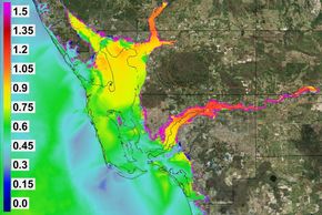
Climatological and Hydrodynamic Model Uncertainties quantifies uncertainties in storm surge models and flood hazard studies by leveraging large datasets of modeled and measured water levels. The work will help the Nuclear Regulatory Commission, the Army Corps, FEMA and other stakeholders include improved understanding of model error structure and more accurate flood hazard estimates.
Dr. Rick Luettich and Taylor Asher (Student)
Image: Increase (m) in the 0.2% (500-year) probabilistic surge hazard in SW FL by including uncertainty
Rutgers University
University of North Carolina-Chapel Hill
Florida Atlantic University
Oyster farms located in shallow coastal habitats provide a plethora of ecosystem functions, including physically interacting with waves and currents to potentially stabilize sediment and protect vulnerable shorelines. Back bay shellfish farms as a model for studying coastal ecosystem feedback systems investigates how oyster farms may act to reduce habitat loss and shoreline loss, ultimately helping the Army Corps and other stakeholders develop shoreline management practices, adaptation planning, and in permitting considerations for future aquaculture operations.
Dr. Daphne Munroe
Photo: Stakeholder (scallop farmer) and research team (background on beach) in southern Barnegat Bay, NJ
Florida Atlantic University
University of North Carolina – Wilmington
Florida Atlantic University
Investigating Impacts of Morphology and Sediment Variability on the Beach and Nearshore Ecosystem evaluates environmental characteristics associated with construction of a shore protection project and influences on the spatial and temporal distribution of black-tip sharks in the nearshore and sea turtle nests on the beach. Benefits include prediction of Outer Continental Shelf sediment dynamics as a result of natural and dredging processes to develop best practices for sand placement to mitigate impacts on the coastal and marine ecosystem.
Dr. Tiffany Briggs
Photo: Aerial photo of beach nourishment construction at Jupiter-Carlin, FL in Dec 2019
Oregon State University
University of North Carolina – Wilmington
University of North Carolina – Wilmington
Quantifying uncertainty of beach/dune evolution models: application to managed and natural post-storm foredune recovery couples numerical modeling and a field campaign effort to quantify the applicability and uncertainty of beach-dune evolution models and better understand the relationships between ecological/environmental conditions and dune evolution. These findings will help the Army Corps and other stakeholders improve the application of developing beach-dune models, which may be used to better predict coastal hazard vulnerability, improve coastal engineering design, and inform decisions for resilience planning.
Paige Hovenga (Student)
Photo: Field data collection, Nov 2019 at Cape Lookout National Seashore, NC, with white square (quadrat)
University of North Carolina – Wilmington
University of North Carolina – Wilmington
University of North Carolina – Wilmington
Living shorelines are a nature-based shoreline management approach that protect coastal habitats and reduce erosion. Multidisciplinary quantification of biogeomorphological impacts of living shorelines studies how living shorelines affect their biological and physical surroundings, their benefits as habitat, and performance as forms of restoration and in building coastal resiliency. This study will provide stakeholders with important information that can influence future project designs and provides information on how living shorelines influence the environment and the coastal communities that invest in them.
Mariko Polk (Student)
Photo: M Taggart and K Signor collect vegetation data at a living shoreline in Pine Knoll Shores, NC
Woods Hole Oceanographic Institution
Woods Hole Oceanographic Institution
Woods Hole Oceanographic Institution
Mechanisms for Dune Failure During Wave Impacts (DUNEX) centers on observations of surf and swash waves and flows, and beach and dune in/exfiltration and moisture content to examine hydrodynamic and morphological processes during wave-dune collision. This information will be shared with colleagues studying swash, groundwater, dune, and geotechnical processes. Benefits to the Army Corps and other stakeholders include improved parameterizations for dune evolution during and following storms, leading to improved models and management decisions.
Dr. Britt Raubenheimer
Photo: P Dickhudt (L), L Gorrell, N Stark, and S Elgar (R) jet a pipe to hold sensors at Duck, NC; Sep 2019
Virginia Tech
Woods Hole Oceanographic Institution
Woods Hole Oceanographic Institution
Impact of Coastal Restoration on Barrier-Island Evolution and Future Flooding addresses the fate of barrier islands and the role they play in altering hurricane surge in coastal communities. Using a large number of computer simulations, both the range of future barrier-island change and the influence of these changes on future hurricane flooding are characterized. Outcomes will equip FEMA, the National Park Service, USGS and other stakeholders with critical knowledge needed to evaluate restoration alternatives (e.g., beach fill and marsh creation in the context of minimizing future hurricane flooding). Co-PIs Robert Weiss and Kyle Mandli
Dr. Jennifer Irish
Photo: USGS pre- (left) and post- (right) Hurricane Ivan (2004) aerial photographs at Gulf Shores, Alabama
University of South Alabama
Woods Hole Oceanographic Institution
University of South Alabama
This project develops a community-informed adaptation pathway for Dauphin Island, Alabama that includes an evaluation of strategies for preventing barrier island breaching during hurricanes. By involving stakeholders in the project adaptation pathway development, stakeholders will better understand and trust its viability and applicability to their own communities, optimizing the benefits for the Army Corps to consider the adaptation pathway in community planning.
Dr. Stephanie Smallegan
Image: Visual summary of discussions w stakeholders about risks and vulnerable areas on Dauphin Island, AL
Indiana University
Woods Hole Oceanographic Institution
University of South Alabama
Identifying and Communicating Coastal Impacts of Storm-Related Events and Other Predicted Climate-Related Stressors to Communities in the U.S. Great Lakes Watershed develops guidance for diverse-sized communities (rural, suburban, urban) to increase their resilience to current and future storm and climate stressors. Through spatial analyses, a survey, and community-based focus groups, this project improves understanding of risk and vulnerability to storms and climate stressors across the Great Lakes region and develops methods to communicate and mitigate risk. The Army Corps and other stakeholders will benefit through improved understanding of: 1) community risk and vulnerability, 2) strengths and resilience characteristics, and 3) feasible strategies to mitigate risk.
Dr. Diane Henschel and Madison Howell
Image: Indiana Social Vulnerability Index and 100-year flood levels
Oregon State University
Woods Hole Oceanographic Institution
Woods Hole Oceanographic Institution

Data-Driven Uncertainty Reduction During Nearshore Events aims to improve models that predict nearshore processes during storms by reducing uncertainty associated with rapidly-evolving sand bars and other seabed features. The project is developing methods to automatically correct models based on data, such as video from beach cameras that indicate how the seabed is changing over time. Benefits to the Army Corps and other stakeholders include improved forecasting capabilities and new techniques for surveying the nearshore environment with remote sensing.
Dr. Greg Wilson
Image: Argus image of waves breaking over sand bar at Duck, NC from camera tower (see shadow in foreground)
Woods Hole Oceanographic Institution
Woods Hole Oceanographic Institution
Woods Hole Oceanographic Institution
Using buried pressure sensors and inland groundwater measurements, Coastal Groundwater, Water Quality, and Sediment Transport during Storms characterizes storm-driven changes in the groundwater flow patterns that affect flooding and pollution transport. Benefits to stakeholders include building collaborations with academic and federal DUNEX participants (Army Corps, USGS) interested in swash, coastal groundwater, and beach evolution; continuing partnerships with local town managers; and developing tools to aid in management of flooding and pollution hazards.
Dr. Britt Raubenheimer
Photo: R Housego (L), B Raubenheimer (C), and L Gorrell (R) burying pressure sensors at Duck NC, Sep 2019.(
Scripps Institution of Oceanography
Scripps Institution of Oceanography
Scripps Institution of Oceanography
Predicting Coastal Water Quality develops advanced modeling tools to predict the timing and extent of poor coastal water quality events by linking hydrodynamic modeling to pollutant transport models. This project also investigates the potential for this project to extend to policy-related economic tools. Partnerships with NOAA, Wildcoast, and Surfrider assist in public outreach and engagement with stakeholders, like this documentary, to improve coastal management decisions.
Dr. Sarah Giddings
Photo: This work builds upon this 2015 dye release experiment. Photo credit: Robert Grenzeback
East Carolina University
Scripps Institution of Oceanography
Scripps Institution of Oceanography
Long-term Impacts of Nourishment Projects on Beach Characteristics and Essential Habitat investigates long-term (>= 5 yrs.) ecological impacts resulting from re-nourishment on sandy, barrier island beaches. Findings will help the U.S. Fish & Wildlife Service and other stakeholders improve understanding of the natural-system response to re-nourishment and inform engineers in the design of future projects that more equitably restore both economic and indigenous ecosystem viability to the reconstructed beach.
Dr. Paul Paris and Dr. Reide Corbett
Photo: R Corbett (L), S Wilkinson (C), and A Leach (R) at Pea Island National Wildlife Refuge, Feb 2020
University of Notre Dame
Scripps Institution of Oceanography
North Carolina State University
Quantifying and reducing uncertainty of marsh accretion through data-model integration of above ground plant productivity fuses data and models to create forecasts of coastal marsh accretion. Using advanced statistical data assimilation techniques, predictions are made that take into account the relative uncertainties of the data and model components.
Megan Vahsen (Student)
Photo: Rhode River in Ches Bay (Global Chg Research Wetland, Smithsonian Envir Research Ctr, Edgewater MD)
North Carolina State University
North Carolina State University
North Carolina State University
Sustainability of Barrier Island Protection Policies under Changing Climates addresses methods to adapt beach and dune nourishment to improve resilience. A stochastic climate emulator is coupled with a library of high-fidelity simulations to identify triggers (beach width, dune height) for renourishment. Benefits to stakeholders include a planning tool that adapts to future climate scenarios.
Dr. Casey Dietrich
Image: Sequence of nourishment and response at Duck, North Carolina
University of South Alabama
North Carolina State University
University of South Alabama
Barrier Island Hydrodynamics and Morphodynamics DURING an Extreme Event addresses the goal of continuously measuring hydrodynamic and morphodynamic processes on low-lying barrier islands during extreme events. This project aims to describe the time-dependency of these processes and their interactions by developing and building low cost sensors that provide the ability to increase spatial resolution of storm processes measurements while minimizing the high risk nature of extreme event deployments. The results will improve the Army Corps' and other stakeholders' understanding of barrier island resilience to extreme events.
Dr. Bret Webb
Image: Low cost wave gauges built with off-the-shelf components, PVC fittings, and 3D-printed backbone.
George Mason University
North Carolina State University
University of South Alabama
Natural and Nature-Based Coastal Defenses: Closing the Gap on the Potential Protection from Marshes in the US East Coast investigates and quantifies the interaction of storm surges and waves with coastal vegetation by measuring hydrodynamic conditions (waves, currents and water levels) and vegetation characteristics, and conducting topographic/bathymetric surveys at two natural areas in the Outer Banks, NC during extreme events as part of DUNEX. This project provides field-based evidence and information to support U.S. Fish & Wildlife Service and coastal communities to safely and cost-effectively rely on natural and nature-based features (NNBF) for local-level resilience against flooding.
Dr. Celso Ferreira and Tyler Miesse (Student)
Image: T Miesse & C Ferreira deploying to measure wave attenuation by marshes at the Deal Island marsh, MD.
University of North Florida
University of North Florida
University of North Florida
Predicting Near-Bottom Currents for Erosion and Deposition Sequences addresses developing a new paradigm for estimating near-bottom currents. This project is analyzing a large set of previously unanalyzed, near-bottom current data from three locations near Duck, NC. The project is developing and utilizing two models to quantify the role of winds, waves and turbulent fluxes in the water column to test theoretical concepts of near-bottom currents against the large set of observations. Such information is expected to be valuable to the Army Corps in understanding short-term and long-term beach erosion/deposition under future sea-level change conditions.
Dr. Don Resio
Image: D Resio & B Dally discuss deployment of two wave gauges offshore of Mayport, FL with MS students
East Carolina University
University of North Florida
University of North Florida
Estuarine bluff shorelines: Inter-relation between erosion processes and development vulnerability integrates scientific information on the risks of bluff erosion with local land use plans and development controls critical to reducing property loss and vulnerability. By incorporating Unmanned Aerial Vehicle (UAV) and RTK-GNSS surveys with hydrological and meteorological sensors we will correlate bluff erosion rates with prevailing environmental conditions in the Neuse River section of the Pamlico estuary. These results along with the expertise of local officials and stakeholders will be used to encourage rural estuarine shoreline communities to consider the best actions for recovery and adaption to bluff erosion.
Dr. Hannah Cooper
Image: Example of damage caused by Hurricane Florence to the estuarine bluff shoreline of the Neuse River, NC; Dec 2019
University of Delaware
University of North Florida
University of California – Los Angeles
Coastal structure design and rehabilitation incorporating stochastic risk and uncertainty performs laboratory experiments to investigate the structure settlement of rock mound structures on sand barriers and the rehabilitation of damaged or aged rubble mound structures. The work will help the Army Corps develop a systematic methodology for evaluating the remaining capacity and structure settlement of a coastal structure for present and future design conditions and for upgrading the deficient capacity if warranted economically.
Dr. Nobuhisa Kobayashi
Image: M Strazzella (L), T Zhu (C), and R Schurr (R) conducted lab experiments in a wave tank at the University of Delaware, Feb 2020
University of California – Los Angeles
University of California – Los Angeles
University of California – Los Angeles
A compound flooding assessment and quantitative modeling methodology for optimizing coastal community resilience examines the pressures of urbanization and climate change that can dramatically increase coastal flood risk. The objective of this research is to develop a hydrodynamic modeling methodology that quantifies both marine (high water levels, waves) and hydrologic (precipitation, pluvial, fluvial) flooding and considers how compound flood risk evolves with infrastructure and intervention. The cities of Long Beach, Seal Beach, Huntington Beach, Imperial Beach, industry and state agencies have been engaged to identify future flood vulnerabilities and guide management decisions.
Dr. Timu Gallien
Louisiana State University
University of California – Los Angeles
Louisiana State University
Evaluation the Distribution and Geotechnical Properties of Outer Continental Shelf (OCS) Sand Resources and Coupled Environmental Responses to Dredging is conducting field work offshore the coast of Louisiana to collect vibracores from a submerged dredge pit near Raccoon Island. As part of the fieldwork, strict COVID-19 precautions were followed and enforced prior to departure. A total of 10 vibracores were collected within and outside of the dredge pit. Gamma ray density profiles of the vibracores indicate that there are primarily under-consolidated clays overlying normally-consolidated clays inside the pit with potentially gas-charged layers present in the sediment. Sands appear to dominate the cores taken outside the pit. Field work and geotechnical testing are ongoing.
Dr. Navid Jafari
Image: Field work off the Louisiana coast, taking vibracores from the Raccoon Island dredge pit.